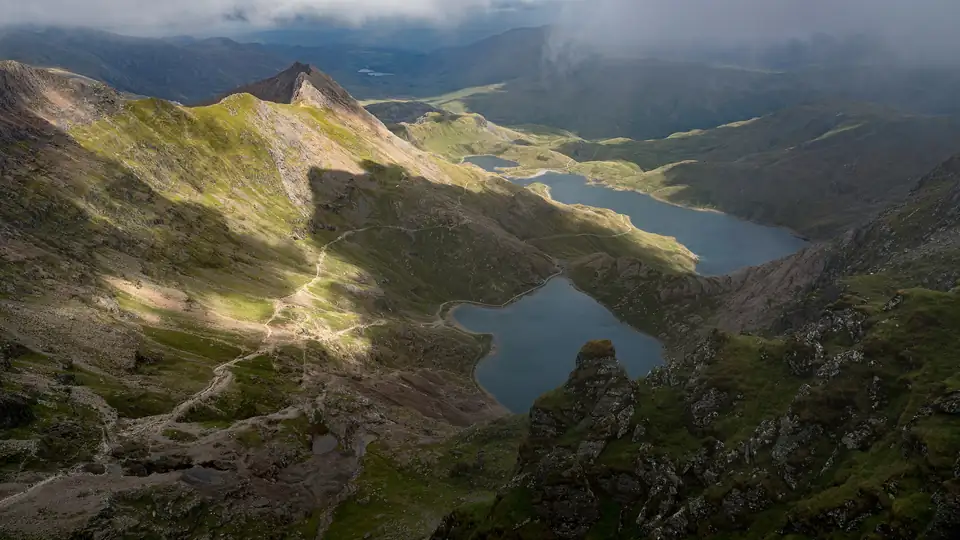
Miners' Track at a glance
Starts gently along Llyn Teyrn, Llyn Llydaw (over the causeway) and Glaslyn, past the remains of the Britannia Copper Mine. The second half is a steep, challenging climb over loose rock and scree to meet the Pyg Track and Llanberis Path.
- Start
- Pen y Pass car park (SH 647 557)
- Grade
- Hard/Strenuous (Eryri)
- Bus stop
- Pen y Pass S1 S2 S5
- Map
- OS Explorer OL17
- Official route
- Eryri route page, PDF and GPX
- Pen y Pass Car park and bus stop
- Llyn Teyrn A gentle start
- Llyn Llydaw Over the causeway
- Glaslyn Past the Britannia Copper Mine remains
- Steep climb Loose rock and scree
- Meets the Pyg Track and Llanberis Path
- Yr Wyddfa summit 1,085 m
- ModerateEryri grade
- Hard/StrenuousEryri gradeMiners' Track
- Scramblehands needed (National Trust)
Plan your Miners' Track walk
1. Pick a path
2. Pick a day
Loading the live forecast…
Forecast loading…
Best day this week
Our own guide, not an official rating: a weather score from the same rules of thumb as the warnings (gusts, rain, cloud, wind chill, freezing level), lowered on days that are usually busy. Busyness uses Eryri's 2025 walker counts by weekday and month, so it shows a typical pattern, not a crowd forecast. Tap a day to see it.
Sunrise hike: what time to start
- You will walk up in the dark: carry a head torch with spare batteries, and a second light. Eryri advises carrying a torch and whistle in case you are caught on a summit after dark.
- It is much colder before dawn and at the top: pack extra warm layers.
- Navigation is harder in the dark: know the path, and carry a map and compass and the skills to use them.
- Early buses may not run yet: check the first bus time, or the parking rules, before you plan the start.
- Go with others, tell someone your plan, and turn back if the weather is poor.
Hour-by-hour forecast: Yr Wyddfa summit (1,085 m)
Wind and gusts in mph. Freezing level in metres above sea level. Forecast data: Open-Meteo.
Before you go, also check the Met Office mountain forecast, MWIS and Eryri's ground conditions reports.
3. Getting there
Map
The route map (OpenStreetMap) loads when you scroll here.
How busy it gets
Monthly walker counts, 2025
One-way counts from Eryri's counter; report total 91,965.
Stay safe
- Ask the AdventureSmart three questions: do I have the knowledge and skills, do I know what the weather will be like, and am I confident I have the right gear?
- In an emergency, dial 999 or 112, ask for the Police, then Mountain Rescue.
- Register your phone for emergency texts before you go: text register to 999.
- Do not walk on the Snowdon Mountain Railway track. Keep dogs on leads near livestock.
- Turn back if the weather turns or you are behind time. The summit will still be there.
Other paths up Snowdon
- Llanberis Path: 14.5 km, 7 hrs
- Pyg Track: 11 km, 6 hrs
- Watkin Path: 13 km, 6 hrs
- Rhyd Ddu Path: 12 km, 6 hrs
- Snowdon Ranger: 13 km, 6 hrs
- Compare all six
Distance km
- Llanberis Path14.5 km
- Pyg Track11 km
- Miners' Track13 km
- Watkin Path13 km
- Rhyd Ddu Path12 km
- Snowdon Ranger13 km
Ascent metres
- Llanberis Path975 m
- Pyg Track895 m
- Miners' Track723 m
- Watkin Path1,015 m
- Rhyd Ddu Pathnot published
- Snowdon Ranger936 m
Time hours (Eryri)
- Llanberis Path7 hrs
- Pyg Track6 hrs
- Miners' Track6 hrs
- Watkin Path6 hrs
- Rhyd Ddu Path6 hrs
- Snowdon Ranger6 hrs
Frequently asked questions
How long is the Miners' Track up Snowdon?
13 km there and back, according to Eryri National Park Authority, with an estimated 6 hours walking.
How much ascent is on the Miners' Track?
723 m.
Where does the Miners' Track start?
Pen y Pass car park (SH 647 557).
Where can I park for the Miners' Track?
Pen y Pass car park (Eryri): £25 up to 8 hrs · £35 for 8–12 hrs · £45 full day. Nant Peris park and ride (Eryri): £5 a day (up to midnight).
Which bus goes to the Miners' Track?
Sherpa'r Wyddfa S1, S2, S5 to Pen y Pass. S1, S2 or S5 from Nant Peris or Llanberis; S1 from Betws y Coed or Caernarfon; S2 from Bangor; S4 from Porthmadog via Beddgelert.
Is the Miners' Track busy?
Eryri rates it "Popular". Its counter recorded 91,965 one-way counts in 2025, busiest in Aug.
Sources
- Eryri: Miners' Track
- Eryri: choosing the right path up Yr Wyddfa
- Eryri: parking in Eryri (prices and payment)
- Eryri: Sherpa'r Wyddfa bus service
- Eryri: Visitor Monitoring Report 2025 (PDF)
Every figure on this page was checked against these sources on 20 October 2026.